Shot on Film! Secret Locations to Photograph in New Zealand's South Island

Written and Photographed by Mike Lindle
This page may contain affiliate links. Learn more in our disclaimer.
If you’re planning a trip to New Zealand, I highly recommend that you spend at least 10 days in New Zealand's South Island. As you drive through these landscapes, it feels like the scenery changes every 2 hours making it incredibly difficult to run out of locations to photograph. Back in 2013, I had the pleasure of exploring New Zealand's South Island with my Canon A1 film SLR, my 50mm f/1.4 Lens, and 2 rolls of Kodak UltraMax 400 film. With limited shutter clicks, here are a few of the best locations that I found to photograph in New Zealand's South Island, I’ve also included a few tips, the cost, the gear I used, and each location on Google Maps.
1. Half Moon Bay - Kaikoura
Kaikoura is a town of an estimated 2,150 residents located 180 kilometers north of Christchurch. On the eastern seaboard of the South Island of New Zealand, it is well-known for it's thriving aquatic biological diversity. Half Moon Bay, just a 20 minute drive north from Kaikoura, reveals 9.1 kilometers of rocky coastal shore crawling with marine wildlife. It's common to see many New Zealand fur seals both on and off the coast and it's a lot of fun to scramble around the rocks while enjoying the black sand beaches, snow-capped mountains, and mystical sunsets.
Pro Tip - The seals are most active during sunrise and sunset!
Cost - Free
Camera - Canon A1 w/ Kodak UltraMax 400
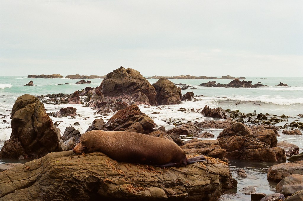
Adult Seal off the coast of Half Moon Bay, New Zealand South Island

Sunset off the coast of Half Moon Bay, New Zealand South Island
2. Ohau Seal Pup Colony - Stream Walkway and Waterfall
After parking on the side of the road 1 km north of Ohau Point Lookout, you'll need to hike along the short trail. The walk only takes about 12 minutes and you'll be greeted by hundreds of swimming seal pups and a scenic waterfall at the end. The baby seals come here to exercise, play, and stay safe while their parents hunt for food during the day. This is technically a natural wildlife refuge so please make sure that you don't litter, feed the seals, or pet them. This disrupts their natural habitat. The seal pups migrate to this area only in winter so make sure you plan accordingly if you want to experience hanging with these beautiful creatures! You can see them between the months of May and September, with peak activity in July.
Pro Tip - Research ahead of time and monitor if this trail is closed, it sustained damage from the Kaikoura Earthquake on November 14th, 2016! Check here for updated closure information.
Cost - Free
Camera - Canon A1 w/ Kodak UltraMax 400

Seal Pup Drying off in the sun, Ohau Seal Pup Colony, New Zealand South Island[
3. Marlborough Sounds - Queen Charlotte Road from Picton
One of the most beautiful areas along the North Shore of New Zealand's South Island are the Marlborough Sounds. If you're coming by ferry from Wellington on the North Island, you'll dock in Picton amongst the sounds. The drive from Picton along Queen Charlotte Road is breathtaking, offering sweeping views of the sounds and D'Urville Island. For this view, make a detour through French Pass and drive until you find your perfect view of the Marlborough Sounds.
Pro Tip - Pack lunch and post up on one of the many picnic tables overlooking the sound!
Cost - Free
Camera - Canon A1 w/ Kodak UltraMax 400

View of Marlborough Sound from French Pass, Picton New Zealand South Island
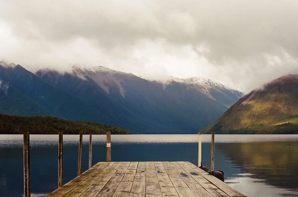
4. The Dock at Lake Rotoiti - Kerr Bay Campground
Lake Rotoiti, previously known as Lake Arthur, is a lake in the Tasman Region of New Zealand's South Island. It lies inside the borders of Nelson Lakes National Park, with sweeping views of Mount Robert and St Arnaud Range over the weathered dock. Take a hike around the lake, or just walk amongst the trees. Spotting Kiwi's is uncommon in New Zealand, but there's more of a chance to spot them here than other regions on the island. (We still couldn't find one.)
Pro Tip - You can drive right up to the dock, so bring a kayak/canoe if you have one!
Cost - Free
Camera - Canon A1 w/ Kodak UltraMax 400

View off the Dock of Lake Rotoiti, New Zealand South Island
5. Franz Josef Glacier - Heli Tour & Hike
There are two glaciers in this region, Fox Glacier and Franz Joesef Glacier. Each glacier provides a different experience. You can book a helicopter tour with a few different companies in town. They'll typically offer scenic flights from Fox Glacier to Mt Cook/Aoraki or Helicopter pick up/drop off guided hikes that will take you to the top of Franz Josef Glacier, and allow you to explore the glacier for an hour or two with your guide; companies usually provide crampons and recommended gear for hiking. These flights range from $300-$450 NZD.
Alternatively, you can access Fox Glacier for free. The trek requires planning and time to properly execute, but you can walk to the base of Fox Glacier from the marked trails and hike amongst the melting ice.
Pro Tip - Book a helicopter tour to view the Glaciers from above and hike atop the ice!
Cost - Approx. $300-$450 NZD
Camera - Canon A1 w/ Kodak UltraMax 400

Franz Josef Glacier Hike, New Zealand South Island

Light Leaked, Stretched, and Destroyed film, Franz Josef Glacier, New Zealand South Island
6. Punakaiki Pancake Rocks and Blowholes
The Pancake Rocks are a popular tourist destination at Dolomite Point. A modern geological mystery, scientists still have not figured out what exactly caused these bizarre rock formations though a few different theories have surfaced. These rocks are heavily eroded limestone layer of alternating hard and soft mud, clay, and lime rich aquatic life. During high tides, the ocean current will push water and air through the blow holes, causing an eruption of mist.
Pro Tip - Time your visit with high tide to observe the Punakaiki Blowholes in action!
Cost - Free
Camera - Canon A1 w/ Kodak UltraMax 400

Punakaiki Pancake Rocks, New Zealand South Island

North Facing View from Punakaiki Pancake Rocks, New Zealand South Island
7. Crown Peak - Top of Crown Range Road
Crown Range Road is New Zealand's tallest main road, winding steeply between Arrow Junction to the south and Wanaka to the north among the Crown Range. The Crown Range lies to the east of the Wakatipu Basin in Otago, New Zealand. Crown Peak is the highest point on the road, meaning this spot is the highest in elevation you can comfortably bring your car in New Zealand. We parked our car about 90 minutes before sunset and hiked to the top to be amongst the clouds for what can be the most spectacular sunset you'll ever experience.
Pro Tip - Park your car, get out, and hike to higher ground!
Cost - Free
Camera - Canon A1 w/ Kodak UltraMax 400

Intense Sunset from Crown Peak, New Zealand South Island

Green dot towards bottom left is where we parked our Mini Van. We hiked across the main road and climbed to the summit of Crown Peak, New Zealand South Island
[caption id="attachment_481" align="alignnone" width="1840"] Intense Sunset from Crown Peak, New Zealand South Island[/caption] [caption id="attachment_482" align="alignnone" width="1840"] Green dot towards bottom left is where we parked our Mini Van. We hiked across the main road and climbed to the summit of Crown Peak, New Zealand South Island[/caption]
8. Milford Sound - Fiordland National Park
Exploring Fiordland National Park is a treat. Greeted by Kias, the New Zealand mountain parrot, and astonishing views, you'll surely want to plan to stay here for more than 1 day. Unfortunately, we only had a morning drive and an afternoon, the drives down to Milford Sound are literally jaw dropping. Once down there, be sure to photograph Mitre Peak and board a cruise to witness the many coastal waterfalls that drop from the peaks of the fjords into the icy depths of the ocean.
Pro Tip - Book your boat trip along the fjords in advance to confirm your seat!
Cost - $40-$60 NZD for Fjord Boat Ride.
Camera - Canon A1 w/ Kodak UltraMax 400

Seals enjoying the sunshine in Fiordland National Park

Enjoying a Cruise through Fiordland National Park, New Zealand South Island
9. Tutoko Bridge - Fiordland National Park
A quick stop on your way to or back from Milford Sound, the view from Tutoko Bridge offers stunning views of the snow-capped rock crags, the river, and this bizarre triangle shaped rock.
Pro Tip - Don't miss this view, it's easy to pass without realizing. Mark it on your map before you lose cellphone service!
Cost - Free
Camera - Canon A1 w/ Kodak UltraMax 400

Strange Triangular Rock in Fiordland National Park, New Zealand South Island
10. Bennett's Bluff - Road Between Glenorchy and Queenstown
The primary road that connects Glenorchy to Queenstown, be sure not to miss this mesmerizing and scenic drive. From the pulloff of Bennett's Bluff you can see Pig Island, Pigeon Island, Lake Wakatipu, and the winding Queenstown-Glenorchy road itself. Witnessing many snow-capped peaks in the distance and the glacier lakes that glow blue is a landscape out of a dream. Many scenes from Lord of the Rings was captured near Glenorchy so keep your eyes peeled and look up a few different locations in the area that allow you to experience Middle Earth first hand.
Pro Tip - Enjoy the drive and check out the touristy Lord of the Rings shops in Glenorchy!
Cost - Free
Camera - Canon A1 w/ Kodak UltraMax 400
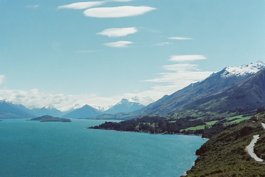
Road between Glenorchy and Queenstown, New Zealand South Island
11. Top of Mt John University Observatory
Mt John University Observatory (MJOU) also known as University of Canterbury Mount John Observatory (UCMJO) is New Zealand's premier astronomical research observatory. It is located at the top of Mt John at the northern end of the Mackenzie Basin in the South Island. Established in 1965, this observatory overlooks the turquoise waters of Lake Tekapo and the surrounding Aoraki/Mt Cook mountain range. This observatory is one of the best locations in the world for stargazing. With the right equipment you can easily spot planets, stars, galaxies, and our own solar system. Dubbed as one of the most accessible observatories in the world with a cafe open to the public at the top, make sure to add this destination to your list when visiting New Zealand's South Island!
Pro Tip - Bring a tripod or telescope for stargazing!
Cost - Free
Camera - Canon A1 w/ Kodak UltraMax 400

View from the Top of Mt John Observatory, New Zealand South Island
12. Bluff Hill Lookout - Invercargill & Bluff
Not many travelers trek down to Invercargill, the southern most city on New Zealand's South Island. Invercargill is a popular destination for those who seek a relatively inexpensive way to get to New Zealand's remote and generally unknown 3rd island; Stewart Island. Invercargill is also a popular port city to stock up on provisions, grab a nice meal, and explore Bluff Hill Lookout. A quick 25 minute drive south from the city will put you on top of this podium enabling you to gaze at a spectacular sunset over Ruapuke and Stewart Island (Rakiura).
Pro Tip - Arrive in winter for a chance to spot the rare Aurora Australis, otherwise known as the Southern Lights (March - September)!
Cost - Free
Camera - Canon A1 w/ Kodak UltraMax 400

Purple Sunset from Bluff Hill Lookout, New Zealand South Island
I hope you found this guide to the 12 Top Secret Locations to Photograph - New Zealand's South Island useful. Someday I hope to go back there with my current professional gear and explore once again. Fortunately, this trip inspired me to learn more about photography and share my experiences with everyone!
If you enjoyed this, check out Focal Collective's other travel guides in the adventure section of our blog Focal Points. Feel free to look through our Artist Interview Series as well!
Author Mike Lindle (@MikeLindle) is a founder of Focal Collective. His goal is to offer advice and tips to those who crave adventure. He lives in Denver, CO but spends most of his working hours exploring California and beyond.